Addresses Guide
Overture maintains over 474 million address point entities. An address represents a physical place through a series of attributes — street number, street name, unit, address levels, postal code, and/or country — together with a point geometry that gives an approximate location of the position most commonly associated with the feature.
Address data can be used for a variety of purposes, which can include:
- Mapping: Addresses may be displayed on the map for reference purposes.
- Geocoding: Addresses are a primary component of high-accuracy geocoding services (i.e. converting text for an address to a complete address with a location).
- Conflation: Addresses can be used to conflate to other data themes (e.g. places, buildings) where appropriate for mapping or other use cases (e.g. refining search).
- Standardization: Parsing an input address into address components based on an existing schema or address model.
- Normalization: Adhering to standard and consistent forms of address components.
- Validation and Verification: Confirming an address exists within a known list of addresses.
 |
|---|
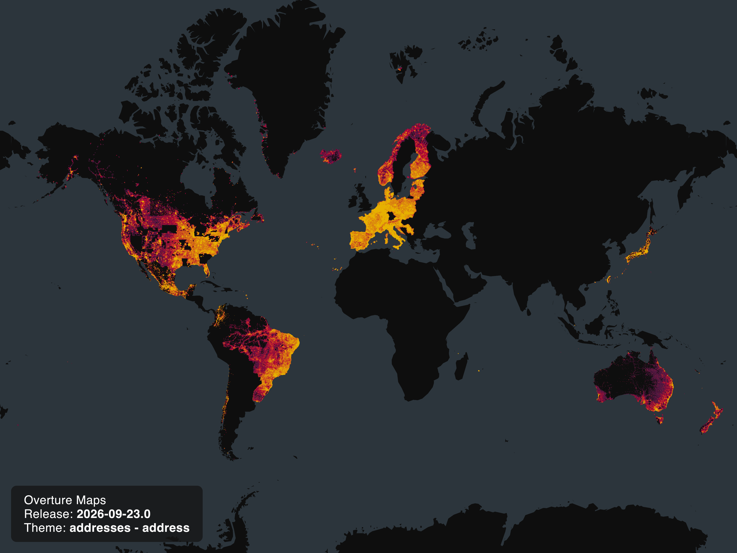
| September 2026 coverage of Overture address data, visualized using H3 cells. |
Dataset description
Feature type descriptions
The addresses theme defines a single feature type, address, which represents a physical place through a series of attributes — street number, street name, unit, address levels, postal code, and/or country — along with a point geometry giving the approximate location most commonly associated with the feature.
Column definitions
Column definitions for the address type are generated from the schema and live in the schema reference.
Sources and licensing
The addresses theme is compiled from over 175 sources. Most address points are distributed through community aggregators — chiefly OpenAddresses and AddressForAll — supplemented by authoritative open datasets published by public agencies, such as the City of New York and the U.S. Department of Transportation. Because it aggregates many independent datasets, the theme carries a variety of source licenses rather than a single overall license. For the specific terms that apply to each source, see the licensing and attribution page.
How we build the dataset
Addresses are assembled from many independent source datasets with minimal transformation, so the processing pipeline is intentionally light.
Filtering. Global filtering for partial data or columns with placeholder values.
Matching. Addresses are matched using exact matching — matches are determined by exact point geometry together with the address properties. All properties, including geometry, participate in the match.
Merging. For matched addresses, a single source is promoted rather than combining attributes. All addresses except for perfect duplicates/matches are released, and no merging of attributes is performed between sources.
Coverage and data quality
Coverage. The addresses theme currently spans 41 countries (see the per-country counts above). Several large countries have only partial coverage, including the US, Germany, and Taiwan. Individual datasets also have varying levels of completeness in their attributes — a dataset may be missing postcodes or have only partial coverage for address_levels, for example.
Address counts, per country
| country | address count |
|---|---|
| AT | 2,516,341 |
| AU | 15,739,608 |
| BE | 6,995,381 |
| BR | 89,887,635 |
| CA | 16,938,808 |
| CH | 3,300,945 |
| CL | 4,199,023 |
| CO | 7,786,046 |
| CZ | 3,020,120 |
| DE | 19,296,806 |
| DK | 3,933,282 |
| EE | 2,230,000 |
| ES | 15,627,615 |
| FI | 3,656,853 |
| FO | 26,428 |
| FR | 26,049,978 |
| GL | 20,297 |
| HK | 176,772 |
| HR | 1,682,125 |
| IS | 139,466 |
| IT | 26,841,754 |
| JP | 19,587,926 |
| LI | 12,966 |
| LT | 1,130,062 |
| LU | 179,533 |
| LV | 549,594 |
| MX | 30,726,687 |
| NC | 41,536 |
| NL | 9,981,787 |
| NO | 3,581,944 |
| NZ | 2,426,460 |
| PF | 2,000 |
| PL | 8,584,407 |
| PT | 5,607,450 |
| RS | 2,681,230 |
| SG | 142,210 |
| SI | 579,979 |
| SK | 1,704,346 |
| TW | 10,174,827 |
| US | 125,367,277 |
| UY | 1,059,027 |
Known quality issues. Address point locations vary from dataset to dataset and most often represent either building centroids, building entrances, points on a road, or parcel centroids. ID stability is limited: the theme relies on identical-value matching rather than a stable matcher, so any change to an attribute or location produces a new ID. Because a stable matcher for addresses has not yet been built, address feature IDs are not published in the GERS registry.
Release artifacts and updates
The addresses theme is released on a monthly cadence. Alongside the data, the following release artifacts are provided:
- GERS registry: Address feature IDs are not currently included in the GERS registry. The addresses theme does not yet have a stable matcher — Overture is seeking engineering support to build one — so address feature IDs are not stable enough to be registered. (See Coverage and data quality for more on ID stability.)
- Data changelog: A changelog accompanies each release.
- Bridge files: Not currently provided for the addresses theme.
Data access and retrieval
Overture's addresses theme data is freely available on both Amazon S3 and Microsoft Azure Blob Storage at these locations:
| provider | location |
|---|---|
| Amazon S3 | |
| Azure Blob Storage | |
Overture distributes its datasets as GeoParquet, a column-oriented spatial data format that is a backwards-compatible extension of Apache Parquet. Parquet (and GeoParquet) is optimized for "cloud-native" queries, which means you can use many developer-friendly tools to efficiently fetch column "chunks" of cloud-hosted data. We encourage users who are new to GeoParquet to consult this guide.
The Getting Data section of this documentation offers instructions for using several tools to access Overture data, including DuckDB and Overture's Python command-line tool. See examples below for addresses.
If you have a particular geographic area of interest, there are several options for using a simple bounding box to extract address data.
- DuckDB
- Python Client
First, follow the setup guide for DuckDB.
DuckDB allows you to pass a bounding box in your query to select features in a specified geogrpahic area.
This example returns address data for Calgary, CA and the surrounding area:
LOAD spatial; --noqa
LOAD httpfs;  --noqa
-- Access the data on AWS in this example
SET s3_region='us-west-2';

SELECT
  *
FROM
  read_parquet('s3://overturemaps-us-west-2/release/2026-09-23.1/theme=addresses/type=*/*', filename=true, hive_partitioning=1)
WHERE
  bbox.xmin > -114.305
  AND bbox.xmax < -113.784
  AND bbox.ymin > 50.854
  AND bbox.ymax < 51.219;
You can find documentation about Overture's official Python Client here.
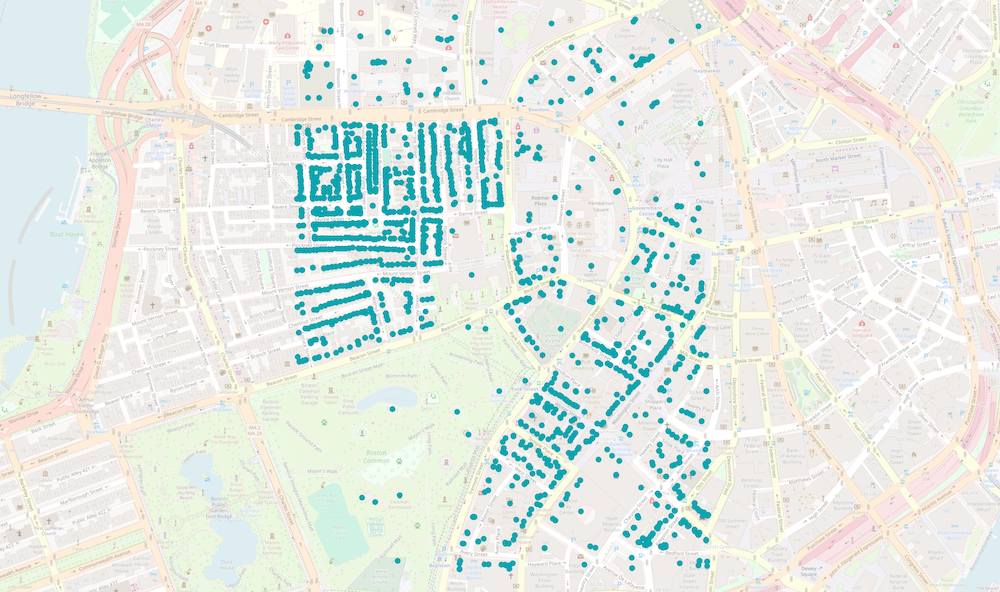
This tool helps to download Overture data within a region of interest and converts it to a few different file formats. In this example, a bounding box is passed to obtain all address data around Boston, MA:
overturemaps download --bbox=-71.068,42.353,-71.058,42.363 -f geojson --type=address -o boston.geojson
This command results in the following address points, displayed in QGIS:
Querying and analysis
Using this query, you can get a count of addresses per country:
LOAD spatial; --noqa
LOAD httpfs;  --noqa
-- Access the data on AWS in this example
SET s3_region='us-west-2';

SELECT
  count(*),
  country
FROM
  read_parquet('s3://overturemaps-us-west-2/release/2026-09-23.1/theme=addresses/type=*/*', filename=true, hive_partitioning=1)
GROUP BY country;
This query will create a shapefile of address data in New Zealand, with limited attributes:
LOAD spatial; --noqa
LOAD httpfs;  --noqa
-- Access the data on AWS in this example
SET s3_region='us-west-2';

COPY (
    SELECT
      id,
      number,
      street,
      unit,
      postcode,
      geometry  -- DuckDB v.1.1.0 will autoload this as a `geometry` type
    FROM
      read_parquet('s3://overturemaps-us-west-2/release/2026-09-23.1/theme=addresses/type=*/*', filename=true, hive_partitioning=1)
    WHERE
    	country = 'NZ'
  )
  TO
    'NZaddresses.shp'
  WITH (
    FORMAT GDAL,
    DRIVER 'ESRI Shapefile',
    SRS 'EPSG:4326'
  );
This query will create a CSV file of address within the State of Utah, using the divisions theme data in a spatial query:
INSTALL spatial;                  -- noqa
LOAD spatial;                     -- noqa

-- Access the data on AWS in this example
SET s3_region='us-west-2';

COPY (
  -- Create a temp table with the state of Utah
  WITH utah AS (
    SELECT
      id AS utah_id,
      geometry AS utah_geom -- DuckDB v.1.1.0 will autoload this as a `geometry` type
    FROM
      read_parquet('s3://overturemaps-us-west-2/release/2026-09-23.1/theme=divisions/type=division_area/*', filename=true, hive_partitioning=1)
    WHERE
      id = '085022383fffffff0167572d4665d6f9'
  ),

  -- Use the geometry of Utah to filter addresses within the state's boundary
  addresses AS (
    SELECT
      *,
      geometry -- DuckDB v.1.1.0 will autoload this as a `geometry` type
    FROM
      read_parquet('s3://overturemaps-us-west-2/release/2026-09-23.1/theme=addresses/type=*/*', filename=true, hive_partitioning=1)
    INNER JOIN
      utah
    ON ST_WITHIN(geometry, utah.utah_geom)
    WHERE
      country = 'US'
  )

  -- Export the places selection to a CSV file
  SELECT
    id,
    street,
    number,
    unit
  FROM
    addresses
)
TO
  'utah_addresses.csv';